


24/06/2026 21:04 - Internacionales
Venezuela was shaken on June 24, 2026 by two powerful earthquakes occurring just 39 seconds apart, in a phenomenon known as a seismic doublet. The first tremor had a magnitude of 7.2 and was later reclassified as a foreshock, while the main event reached a magnitude of 7.5, according to the United States Geological Survey (USGS).
The epicenter was located near the city of San Felipe, Yaracuy state, in northwestern Venezuela, approximately 200 kilometers from the capital Caracas. The depth was approximately 10 to 21 kilometers, classifying it as a shallow earthquake, which amplifies its intensity on the surface.
Note: For context, San Felipe is the capital of Yaracuy state, located in Venezuela's agricultural heartland. Caracas, the nation's capital and largest city, sits in a valley along the Caribbean coast and is home to over 2 million people.
| Main magnitude | 7.5 |
| Foreshock | 7.2 (39 seconds before) |
| Epicenter | Near San Felipe, Yaracuy state |
| Depth | 10-21 km (shallow earthquake) |
| Distance to Caracas | ~200 km (about 124 miles) |
| Local time | 6:04 PM (22:04 GMT) |
Venezuela is located on the northern coast of South America, bordering the Caribbean Sea. It's about:
The Caribbean islands of Aruba, Curaçao, and Bonaire (known as the ABC islands) are located just off Venezuela's northern coast, about 50-80 km north of the mainland.
The U.S. Tsunami Warning System initially issued an alert for Puerto Rico, the U.S. Virgin Islands, Aruba, Curaçao, and Bonaire. However, these alerts were later cancelled when the risk of dangerous waves was ruled out. Authorities recommended staying away from coastal areas as a precautionary measure while the alert remained active.
Puerto Rico and the U.S. Virgin Islands are U.S. territories in the Caribbean, located approximately 600-700 km north of Venezuela. They are popular tourist destinations with combined populations of over 3 million people.
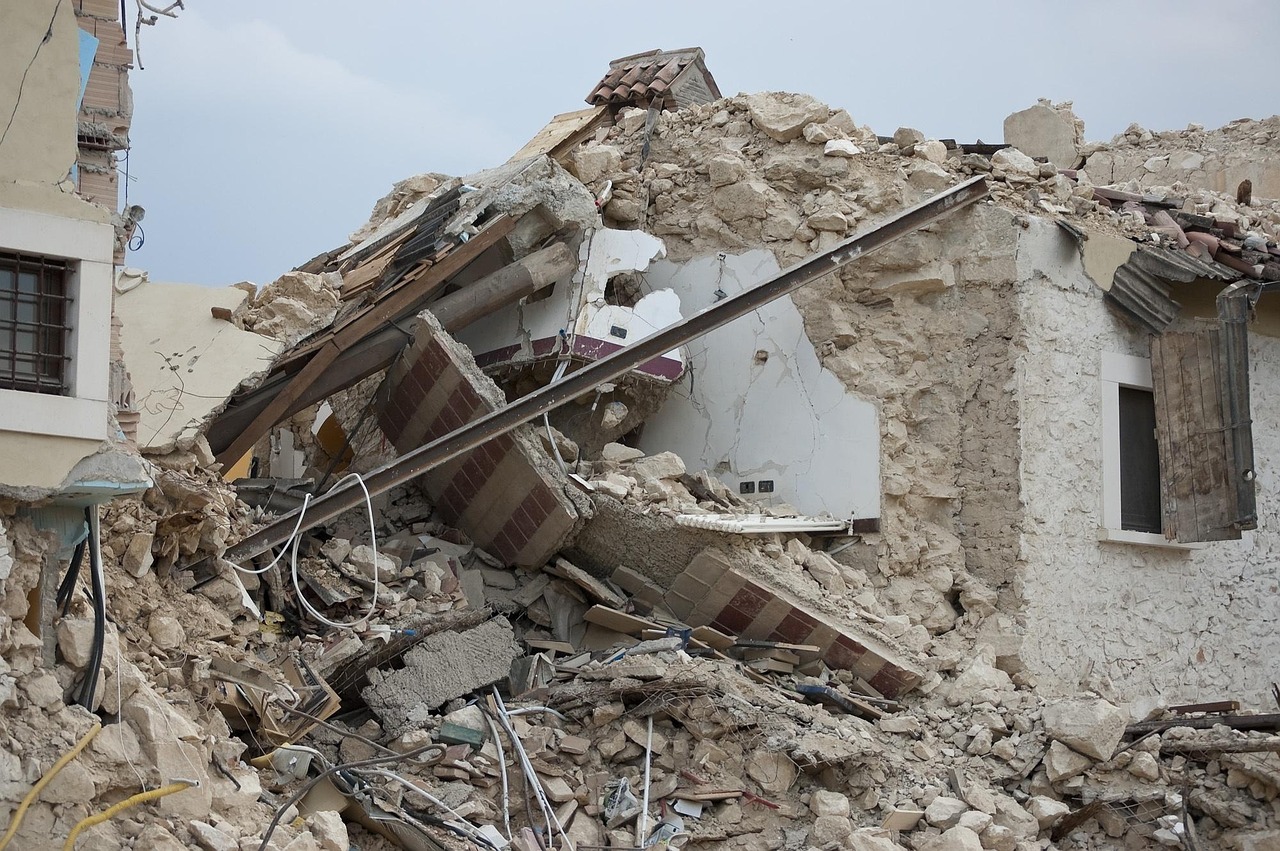
Venezuelan Interior Minister Diosdado Cabello confirmed that building and house collapses were recorded in several areas of the capital. The most affected neighborhoods include:
Electricity, natural gas, and internet services were interrupted as a precautionary measure in various parts of the city.
Authorities immediately deployed:
Minister Cabello urged the population to remain calm and evacuate buildings due to possible aftershocks. As of now, there is no official information regarding fatalities.
A seismic doublet is a phenomenon where two large earthquakes occur within seconds of each other in the same geographic area. The second event is typically larger than the first. In this case, the USGS identified the 7.2 earthquake as a foreshock to the main 7.5 earthquake, occurring just 39 seconds apart.
Venezuela is located in one of the most seismically active regions of northern South America, situated on the boundary between the Caribbean and South American tectonic plates. The interaction between these plates generates frequent movements, especially near the Boconó fault system, considered one of the most important in the country.
Tectonic plates are massive slabs of Earth's lithosphere that move and interact at their boundaries, often causing earthquakes and volcanic activity. The Caribbean plate is moving eastward relative to the South American plate, creating significant seismic stress.
| Year | Event | Estimated Magnitude |
|---|---|---|
| 1812 | Holy Thursday Earthquake (Caracas, La Guaira, Mérida) | ~7.7 |
| 1967 | Caracas Earthquake | ~6.7 |
| 2018 | Earthquake in Sucre state | 7.3 |
| 2026 | Earthquake in Yaracuy (current) | 7.5 |
Note: The 1812 Holy Thursday Earthquake is one of Venezuela's deadliest natural disasters, destroying much of Caracas and killing an estimated 15,000-20,000 people. The 1967 Caracas earthquake caused approximately 300 deaths and significant infrastructure damage.
Venezuelan opposition leader María Corina Machado expressed solidarity with those affected through the social network X: "May God protect every Venezuelan, our families, and our homes. Today, more united than ever." The message called for strength, serenity, and solidarity during this emergency.
María Corina Machado is a prominent Venezuelan politician and opposition figure who has been a vocal advocate for democratic reforms in the country. Her message of unity reflects the national spirit during times of crisis.
Sources: Infobae, BBC Mundo, CNN en Español, USGS.

Alfredo S. Quiroga